1 / 6
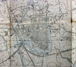
British WWI Trenh Map Belgium, Ypres Sector 1917
Sold
$75.00
—
Description
Original period manufacture. Linen-backed, folding paper map of the Western Front in Belgium, Ypres Sector corrected to 20 June 1917. A series of five major battles/offensives occurred near the city of Ypres during WWI. German trenches are shown in red, the British in blue. Two American Divisions of the AEF fought near here in late October, early November 1918. Map measures roughly 28 x 35 inches. Shows honest age and service use.
Dealer Info
Dealer Info
-
 Clarkdale, AZ · United States