1 / 7
WW2 German Luftwaffe Navigationskarte – 1:2000000 NAVIGATIONAL MAP – GERMANY
Available
$299.99
—
Description
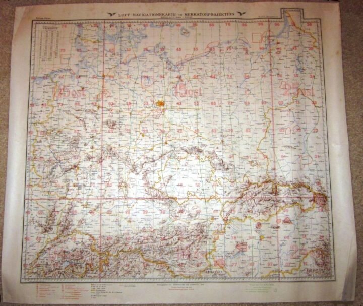
You are bidding on a SUPERB example of a WW2 German Luftwaffe 1:2000000 Luftwaffe Luft-Navigationskarte in Mercator projection! Used for long-range aerial navigation and operational planning, these large-format air navigation maps were specifically produced for Luftwaffe flight crews and command navigation units. Measuring approx. 24″ x 27″ size, this example covers a broad region of Germany and surrounding areas and was intended for strategic aviation use rather than ground operations.Luftwaffe Luft-Navigationskarten of this type were issued under the authority of the Generalstab der Luftwaffe and utilized Mercator projection to assist with heading, distance calculation, and route planning over long distances. These maps were fundamental tools for bomber, transport, and reconnaissance units, providing standardized grid references, air navigation markings, and terrain features critical for wartime aerial operations. Issued examples like this were actively used throughout the early and mid-war period.Dated 1940, this map is printed on original wartime paper and remains fully readable and usable, with its original full-color printing intact. Condition is consistent with period military use and storage and may include fold lines, edge wear, minor tears, light staining, and handling marks. Not a modern reproduction or later reprint. The map retains clear color differentiation, legible text, and visible navigation and grid details. A VERY NICE and SCARCE addition to any Luftwaffe, aviation, or WW2 militaria collection!
Dealer Info
Dealer Info
-
 Thousand Oaks, CA · United States