1 / 11
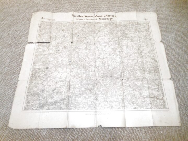
WW1 German Army Map – NIVELLES WAVER MONS CHARLEROI – BELGIUM 1916 – NICE!
Available
$149.99
—
Description
You are bidding on an original WW1 German / Prussian Military Field Map, dated 1916, and covering the regions of Nivelles, Waver, Mons, Charleroi…including reference to the Maubeuge area. This is an authentic period-issued map produced for German army operational use during the First World War.During World War I, German military maps such as this were used by staff officers, artillery units, and field commanders for planning troop movements, coordinating rail and road networks, and establishing artillery reference points. Large-scale regional maps like this were especially important in Belgium and northern France, where fortified cities, rail hubs, and industrial centers played a critical strategic role throughout the war.Printed on heavy paper stock and is dated 1916, marked as a first edition issue. The map includes a printed scale bar and German-language legends, and shows highly detailed terrain, elevation contours, road and rail infrastructure, and populated areas. There are numerous period hand-drawn annotations present, including several numbered circled reference points, consistent with wartime tactical or artillery planning. Condition is FAIR to GOOD for its age, with multiple tears along fold lines, edge losses, small holes from period tack mounting, and general handling wear. A bit fragile in areas, due to the age. Despite the wear, the map remains structurally intact and historically significant, with all major geographic details clearly legible. PERFECT for any collection or display!
Dealer Info
Dealer Info
-
 Thousand Oaks, CA · United States